RESSEARCH &
INVESTIGATIONS
WITH REDLEAF GROUP
Case Study: Mapping Matters of Local Environmental Significance (MLES) in the Fraser Coast Region

INTRODUCTION
This report outlines the comprehensive process undertaken to identify and map Matters of Local Environmental Significance (MLES) in the Fraser Coast region. While national and state-level environmental significance matters are well-documented, local governments are encouraged to recognise and map natural values unique to their specific areas, including flora, fauna, and ecosystems.
KEY COMPONENTS OF THE REPORT
This investigation served as a valuable resource, offering the following key components:
- Framework for Identifying MLES: This document presents a structured framework for identifying MLES within the Fraser Coast region.
- Mapping Methodology: It outlines the methodology used for mapping MLES, providing insights into the data and techniques employed.
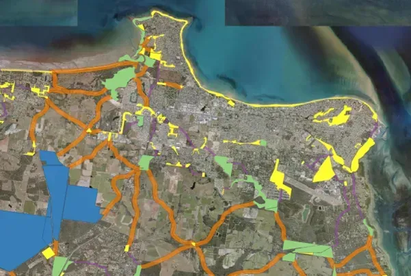
- Mapping Outputs: The report showcases the mapping outputs, highlighting the identified corridors, habitat nodes, core areas, aquatic corridors, and rehabilitation zones.
- Recommendations: Lastly, it offers recommendations based on the findings and assessments, guiding future actions and priorities.
METHODOLOGY
The identification of MLES within the Fraser Coast region commenced with the establishment of a structured framework that categorized values into three primary groups:
- Corridors: These include regional corridors, riparian corridors, established corridors, enhancement corridors, enhancement urban corridors, and stepping stone corridors.
- Biodiversity Areas: This category encompasses core habitat areas, established nodes, enhancement nodes, areas of species richness and diversity, climate change adaptation and refugia areas.
- Ecosystems: Least concern regional ecosystems, ecosystem representation and uniqueness, coastal habitats, urban bushland, local significant species habitat, rehabilitation areas, and ecosystem buffers.
To ensure a comprehensive understanding of these categories, an Expert Panel, composed of local ecological specialists, actively participated in workshops, nominating values for the sub-categories. This approach tapped into extensive local ecological knowledge.
The utilisation of GIS spatial modelling techniques was pivotal in identifying potential linkages and ecological corridors across the study area. Selected criteria, datasets, and mapping methods were employed to map corridors, habitat nodes, core areas, aquatic corridors, and rehabilitation zones. Guiding principles, such as connecting habitat nodes to neighbouring areas within a certain threshold distance, were crucial in achieving effective corridor mapping.
Only values supported by scientifically robust, spatially mapped evidence were recommended as MLES by the Expert Panel.
RESULTS
This comprehensive research and mapping endeavour significantly contribute to the understanding and preservation of local environmental significance within the Fraser Coast region, serving as a valuable resource for conservation and sustainable development efforts.
